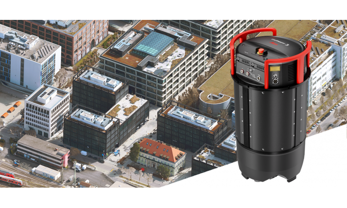
CityMapper-3 is the first CityMapper to feature a Leica MFC250-based camera system, powered by Sony’s IMX811 sensor. (Image courtesy: Leica Geosystems/Hexagon)
The article introduces the Leica CityMapper-3, a new airborne hybrid system developed by Leica Geosystems, part of Hexagon. This innovative system integrates imaging and Lidar technologies into a single, configurable platform, aiming to enhance operational efficiency in complex urban and regional mapping projects. By combining the latest camera and Lidar technologies, CityMapper-3 reduces the number of flights required to meet project specifications, thereby streamlining data acquisition. The system features a Leica MFC250-based camera powered by Sony’s IMX811 sensor, which delivers up to a 30% increase in acquisition efficiency. This advancement addresses the growing demand for richer spatial data while maintaining flight time and costs under control, making it a significant development in the travel and mapping technology sector.
Key Points:
Leica CityMapper-3 is an integrated airborne system combining imaging and Lidar technologies.
The system features a Leica MFC250-based camera with Sony’s IMX811 sensor, increasing acquisition efficiency by up to 30%.
CityMapper-3 is designed to reduce the number of flights needed for mapping projects, improving operational efficiency.
The system aims to deliver richer spatial data while controlling flight time and costs, addressing the pressures on airborne mapping systems.
Actionable Takeaways:
Enhanced Operational Efficiency: The integration of imaging and Lidar technologies in the Leica CityMapper-3 reduces the number of flights required for mapping projects. This efficiency gain can lead to significant cost savings and time reductions for travel and logistics companies, making it a valuable tool for optimizing urban and regional mapping operations.
Increased Data Acquisition Efficiency: The use of a Leica MFC250-based camera with Sony’s IMX811 sensor in CityMapper-3 results in a 30% increase in acquisition efficiency. This improvement allows for more comprehensive data collection in a shorter timeframe, which can enhance the accuracy and detail of spatial data used in travel planning and urban development projects.
Alignment with Industry Trends: The development of the Leica CityMapper-3 reflects the broader trend in the travel industry towards leveraging advanced technologies to improve efficiency and data quality. As cities and regions increasingly rely on rich spatial data for planning and development, systems like CityMapper-3 are likely to become essential tools for travel and logistics professionals seeking to stay competitive and innovative.
Contextual Insights:
The introduction of the Leica CityMapper-3 aligns with current industry trends that emphasize the integration of advanced imaging and Lidar technologies to enhance operational efficiency and data quality. As the travel industry continues to evolve, the demand for precise, high-resolution spatial data is growing, driven by the need for smarter urban planning, efficient logistics, and improved travel experiences. Thought leaders in the travel sector are increasingly recognizing the value of such technologies in providing actionable insights that can inform decision-making processes. The Leica CityMapper-3, with its innovative approach to combining imaging and Lidar, exemplifies this trend by offering a more efficient and effective solution for complex mapping projects. This development not only supports the operational needs of travel companies but also positions them to leverage richer data for strategic planning and competitive advantage. As the industry moves forward, tools like CityMapper-3 will likely play a crucial role in shaping the future of travel technology, enabling more informed and data-driven strategies.